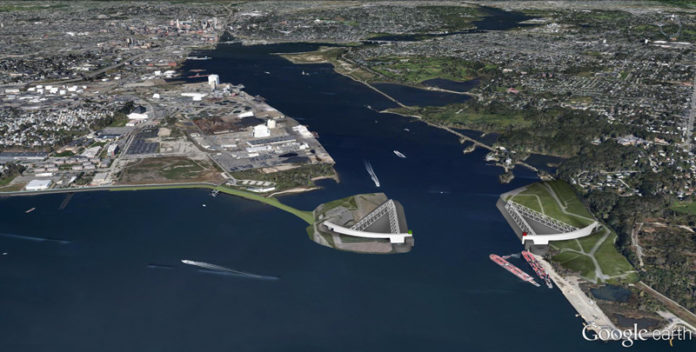
Seventeen University of Rhode Island students recently analyzed the Providence harbor to recommend ways to make it more resilient to severe weather and sea-level rise, including building a 2,000-foot-long, 25-foot-tall barrier.
The students, in a sustainable-design studio course led by assistant professor Austin Becker and professor Will Green, presented the project and their recommendations to representatives of a dozen state and local agencies.
The students proposed building the barrier from Fields Point to the petroleum offloading facility in East Providence, similar to the Maeslantkering storm barrier that protects the port of Rotterdam in the Netherlands.
The proposed barrier would be designed to withstand a Category 3 hurricane and to hold back a 21-foot storm surge. As a result, the current hurricane barrier at Fox Point would be removed, freeing up waterfront land closer to the center of the city.
Students also recommended enhanced emergency-management plans along the waterfront, modifications to businesses’ insurance policies, moving computers above the ground-floor level and creating debris-management plans. In addition, they recommended landscape improvements, as well as a bicycle path around the area, and rain gardens to aid in stormwater collection, treatment and infiltration.
Becker, a professor of coastal planning, policy and design, said that estimating the costs of implementing such a plan fell outside the scope of the student project, and that it would likely take decades to implement, considering the design and permitting processes alone. Becker said the students used software products such as ARCGIS, Sketchup, and AutoCAD to create their designs.
“It’s always good to have food for thought,” Stone said.
Still, while only a student project, Becker said it helped start a conversation about storm resilience, which leads into a related yearlong project that Becker and professor Richard Burroughs are starting this winter to analyze the effects of a Hurricane Sandy-scale event on the Providence waterfront and the state as a whole.
Hurricane Sandy, a Category 3 hurricane which struck in October 2012, damaged hundreds of thousands of homes along the East Coast, killing 117. Sandy is considered the second-costliest tropical cyclone on record, after Hurricane Katrina in 2005.
Eighty percent of the $120,000 project is being funded by the Federal Highway Administration, with 20 percent funded by the R.I. Department of Transportation.
Corey Bobba, program-development team leader for the Federal Highway Administration, Rhode Island Division Office, said the study marks the first of its kind for the Ocean State, and follows a recent Federal Highway Administration order about transportation-system preparedness and resilience to climate change and extreme weather events.
Going forward, he said the professors may focus on another area, such as Quonset Point, or Point Judith, or Newport, but this funding is only for the Providence harbor study.
“We’re really looking at the movement of people and goods … also the energy that comes in and out of the port of Providence. How does that get to the general public? The type of commerce happening there and how to preserve it,” Bobba said.
Bobba said the research the professors create is important because it will help stakeholders plan for different scenarios, and create long-term goals.
With sea levels rising and storms intensifying, Becker said these kinds of projects are likely to be on the table in the long-term because they take so long to implement.
The research project, Becker said, plays upon a larger theme of “coastal resilience in the face of climate change and what it means for water-dependent industries like a seaport. Ninety percent of world trade moves by ship. … It’s important to start thinking about this now.”
Becker said they are focusing on Providence harbor first in order to develop a method that can be used to better understand potential impacts and resilience strategies in other areas around the state. In future work, he said, they would also create storm scenarios to explore potential impacts in the other study areas.
“The purpose of the study is not to develop specific recommendations. Rather, it is to develop a more robust understanding of the potential impacts of a major storm and to take the pulse of the stakeholder community with respect to some potential (hypothetical) long-term resilience strategies,” Becker said. •


